Salavoura, Eleni. “Eastern Attica in the Postpalatial times and a new Late Helladic IIIC cemetery at Porto Raphti.” CHS Research Bulletin 10 (2022). http://nrs.harvard.edu/URN-3:HLNC.ESSAY:102284672.
Early Career Fellow in Hellenic Studies 2021-22
Introduction
A storm of events led to the Collapse of the Palatial System in the eastern Mediterranean at the end of the 13th BC century, with a serious impact on the Aegean, too. The 12th century that followed the fall of the Mycenaean palaces is characterized by upheavals and intense mobility of populations [fig. 1]. Although we may be far from identifying the primary cause or causes of this collapse, it is a common belief that the destructions and the significant changes have hit mainly the palatial centers. Most of the other Aegean regions, sometimes described as peripheries, not only did survive, but in a short time some of them flourished, as the centrally administered palace economies gave way to more dispersed forms of economic organization. Attica and especially its eastern coast is such a case of resilience in this closing stage of the Mycenaean civilization.
| Period | Approx. date | Main developments |
| Late Helladic III A-B | 1370-1200/1190 BC | Palaces in mainland Greece |
| Late Helladic III C -early | 1200/1190-1150 BC | Destruction of the palacesReconstitution of new communities |
| Late Helladic III C -middle | 1150-1100/1090 | HeydayWell established overseas communications |
| Late Helladic III C -late | 1100/1090-1060 | Recession |
| SubMycenaean | 1060-1000 BC | Severe economic and cultural depression |
| ProtoGeometric | 1000-900 BC | Ever-increasing recovery |
Athens and Attica at the close of the 13th c. BC
The pattern of monumental tombs in Late Helladic Attica (Marathon, Thorikos, Menidi, Spata) suggests that political power remained decentralized for centuries. The Attic countryside was densely inhabited, suggesting that the main subsistence strategy was agricultural exploitation. Thorikos, a key site in Attica, connected to Laurion mines, continued to be a main source of lead and silver in the 13th c BC.1 However, Thorikos –according the available data– is in decline in the palatial times. It is an open question whether Athens was exploiting the metal deposits from then on or whether the mines were controlled by a center outside Attica.2
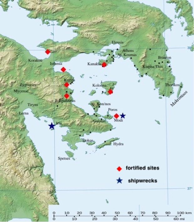
The existence of a palace on the rock of Acropolis has been doubted in the recent scholarship,3 however ‘we must keep in mind that the prehistoric Acropolis was in a real sense a victim of the citadel’s later history’.4 On the Acropolis and in Attica there are no traces of destruction, as there are at Mycenae, Tiryns, Midea, Pylos and Thebes.5The massive Cyclopean wall around the entire brow of the citadel was erected rather late, in the last decades of the 13thc. It is equivocal whether all of Attica was by now fully unified and that the lord of the Acropolis ruled it. However, houses over the bottom of the old NE ascent of the Acropolis appear to have been inhabited for a brief period at the end of the 13th (Late Helladic IIIB2), until the beginning of the 12th c. (Late Helladic IIIC early), 6 while use of the underground fountain on the north slope of Acropolis may have ceased in this same period.7 It is believed that some danger led the population to the foot of the wall, while the abandonment of the houses also remains a mystery as the inhabitants left leaving their household effects in place, never to return.8 The concealment of a hoard containing 33 bronze items within a schist wall of a house built along the south wall of the Acropolis is also dated to the beginning of the 12th c.9 The phenomenon of hiding “treasures” is widespread in mainland Greece and Cyprus, as well as in Near East. Aside from the conditions of social and economic instability, it is related to piracy and the development of fortified sites, with direct access to the sea primarily on islands, but also in mainland Greece, on Crete and on Cyprus.10 Fortified settlements have not been located in Attica, in contrast to the Saronic gulf and the Cyclades. In these turbulent times, in the last decades before and after the palatial collapse, rocky islets are also used as trading posts, such as Modi near Poros, Evraionisos in the Saronic Gulf or cape Leontari on Makronisos.11 From these small stations goods could easily have been transported to the nearby Mycenaean ports of Attica, the Argolid and the Saronic, and vice versa [fig. 2].
Thus the major change in Attica did not happen at the end of the 13th c., but few decades later. Athens was not completely abandoned, but it lost its importance as can be deduced from the meager remains of pottery of the second half of the 12th c.12 At the same time, the settlement of Ayios Kosmas on the west coast of Attica was abandoned by its inhabitants and a flourishing settlement and an important neighbouring workshop, at Alimos: Kontopigado, were also destroyed. Moreover, all the cemeteries along the west coast (Alyki Voula, Varkiza/Vari), and the majority of those in the inland plain of Mesogaia (Glyka Nera/ Fouresi, Vourvatsi, Spata, Merenda, Brauron), cease to be used in the first decades of the 12th c. 13
Eastern Attica from Late Helladic IIIC early to Late Helladic IIIC middle
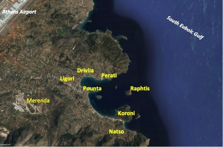
The LH IIIC early is a transitional phase during which old communities, such as Brauron, are gradually diminished,14while new communities are reconstituted. At this time the bay of Porto Rafti becomes a hub [fig. 3].
The coastal town of Porto Rafti lies 40 kilometers southeast of Athens and on the South Euboic Gulf. It is the most well protected port on the east coast and thus an excellent harbor, highly suitable for small vessels. It is also situated at the end of the route connecting the coast with the Mesogeia plain and thence it gave the whole region direct access to the Aegean. In antiquity it was the site of two Attic demes, Prasiae at its southern end and Steiria at its northern.15
The foundation of a wealthy community relying on long-distance sea-trade, at Perati, a site with imports from Cyclades, Dodecanese, Crete, Cyprus (seals), Egypt (scarabs, glass) and Syria (iron knife, seals) denotes that the centre of importance shifted to the east coast of Attica. Most of the Oriental imports from this period on the Greek mainland come from Perati. 16 That time, after the middle of the 12th c., a kind of stability has returned in the Eastern Mediterranean, perhaps because the danger of the ‘Sea Peoples’ has passed and the overseas communications are well established.
A smaller chamber tomb cemetery at Ligori, 3 kms from Perati continued to be used until the end of the 12th c.17A third chamber tomb cemetery of the same date, 1,7 km western from Perati, opposite the main port of Mesogaia, at Porto Raphti: Drivlia, was identified and partly excavated few years ago by the Hellenic Ministry of Culture (Ephorate of Eastern Attika).18 The original size of the cemetery is hard to assess, but the dense layout of the tombs, their location in the middle of the slope and the identification of some more unexcavated chamber tombs in the adjacent properties, testify the existence of a wider Mycenaean cemetery in that place. Its chambers are relatively small, with one to three persons buried into them.
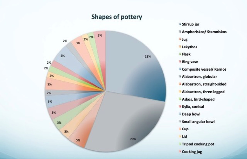
According to the pottery the cemetery is contemporary with Perati (phases I, II, III), and most burials belong to the middle of the 12 th c. Macroscopically the clays of the two sites do not differ, with a few exceptions. The most popular shape is the stirrup jar, in different sizes (large, medium, small, tiny). Amphoriskoi/ stamniskoi (FS 59) are also found in an equal percentage. The other shapes are represented almost equally with a few examples each [fig. 4].
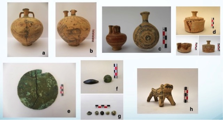
An octopus stirrup jar stands out among the finds, which does not show close affinities with similar Attic vases (from Perati, Athens, Keratea, Ligori), but it belongs to the same workshop with a stirrup jar from Palea Epidauros in the Argolid. Stirrup jars of the so called Closed style are also present, as well as miniature vessels, handmade ware and a peculiar incense burner. An hybrid animal-shaped figurine, possibly a lion, was dedicated to a child burial. The burial gifts comprise also a bronze mirror, a few glass paste beads and a conical button from steatite, while a sphendonoid hematite balance weight and a second of the dome-shaped type confirm the maritime and commercial activities of the inhabitants [fig. 5 a-h]. They are compatible to the Aegean and the eastern Mediterranean standards, their light weight are suited for weighing small quantities of presumably precious goods.
The site of the settlement or settlements on the mainland to which the cemeteries of Ligori, Drivlia, and Perati belonged is still unknown. Although we must look for them in the mainland around the bay, the only located settlement until recently was that on the rocky islet of Raphtis.19 Despite the obvious drawbacks connected to that place, it provides protection against attackers and at the same time it controls the entrance to the gulf. The prevailing view was that Perati belongs to a nucleated settlement rather than a conglomeration of small ‘villages’ as appears to be the case in Athens. But the revelation of the Drivlia cemetery along with the identification of at least three other sites of the same date in the vicinity (Pounta, Koroni, Natso), indicates a more complex settlement pattern [fig. 3].20
Perati and Drivlia were apparently newly established in the 12th c. and the question of where the inhabitants came from is still open. Most scholars assume that their foundation had to do with the desire to exploit the metal resources of southern Attica.21 This hypothesis is supported by three LH IIIC vases from Keratea, now in the Karlsruhe Museum,22 among them an octopus stirrup-jar, a product of the Perati workshop. Although such a connection is also traced through the silver and lead artifacts from the Perati cemetery, there is no sufficient documentation for the extent and quality of these relations.
In any case, the possibility that some merchants, who travelled on behalf of the palaces before the collapse, fled during the chaos to make a new foundation in east Attica, sounds plausible.23 On the other hand, as the majority of the pottery from Drivlia and Perati is of local clays, it is also reasonable to suggest that people from the inland plains of eastern Attica (Brauron, Merenda, Spata), possibly also from the western coast, moved to the eastern coast.
Conclusions
To sum up, in the palatial times, when a Mycenaen penetration is apparent in the Argolic and Saronic gulfs, the channel between the west coast of Attica and the eastern coast of the Argolid was in more intensive use. After the fall of the palaces, Mycenae seems to be more isolated, while Tiryns retained its continuous contacts and trade with Cyprus and the Near East.24 The western coast of Attica is gradually abandoned and eastern Attica through the safe port of Porto Raphti was involved in the decentralized commercial networks that characterized the Mediterranean during the 12th c. BC.25 It starts to become clearer that besides Perati, smaller (?) satellite sites participated in the creation of a ‘microcosm’ in east Attica, as part of a wider network. LH IIIC middle flourishing sites on the shores of the Euboean Gulf, such as Lefkandi and Kynos, have also gained from the re-activation of trade with the Eastern Mediterranean in the area. A Mainland pottery style spread at this time across the Aegean, the ‘East Mainland koine’ and covers the Argolid, Attica, Euboea (Lefkandi), Cyclades (Kea, Siphnos, Paros), Dodecanese (Kos, Kalymnos, Rhodes) and Chios (Emporio). 26
Contacts within and outside the Aegean seem to have been seriously disturbed at the end of the 12th c., when all the above mentioned sites in eastern Attica were abandoned. This is an additional proof that these communities were strongly depended on sea trade. Our knowledge about the 11th and 10th c. BC in this region is extremely limited, in contrast to Athens, where a number of new single burial cemeteries were established on and around the Acropolis and in the area of Kerameikos. Besides Athens, it is now evident that in the Submycenaean period west Attica became the region’s new center with the addition of Eleusis and Salamis.27
However it is clear that the Mycenaean world does not vanishes with the fall of the palaces, on the contrary times of crisis and recession are for some people times of new opportunities.
Bibliography
CVA, Karlsruhe I: Hafner G., Corpus Vasorum Antiquorum Deutschland 7, Karlsruhe, Badisches Landmuseum I, München 1951.
Deger-Jalkotzy, S. 2008. “Decline, Destruction, Aftermath”, In: Shelmerdine C. (ed), The Cambridge companion to the Aegean Bronze Age, 387-415. Cambridge-New York.
Gale N.H.– Kayafa M. – Stos-Gale Z.A., 2009. “Further evidence for Bronze Age production of copper from ores in the Lavrion ore district, Attica, Greece”. In: Giumlia-Mair, A. – Craddock, P. – Hauptmann, A.– Bayley, J.– Cavallini, M.–Garagnani, G.– Gimour, B.– La Niece, S.– Nicodemi W.– Rehren, T. (eds.), Proceedings of the 2nd International Conference: Archaeometallurgy in Europe, Milan, 158-176.
Hurwit, J. M. 1999. The Athenian Acropolis, History, mythology and archaeology from the Neolithic era to the present. Cambridge.
Iakovides, S. 1980. Excavations of the necropolis of Perati. Los Angeles.
Iakovidis, S. E. 2006. The Mycenaean Acropolis of Athens. Athens (The Archaeological Society at Athens Library No 240).
Kakovoyianni-Apostopoulou, O. 1986. “Δύο νέα μνημεία Υστεροαρχαϊκής πλαστικής από τις Πρασιές”, In: Η. Kyrieleis (ed.), Archaische und Klassische Griechische Plastik, Band I, 171-5. Mainz am Rhein.
Kakavoyianni, O.- Douni, K. 2001-4. “Πόρτο Ράφτη (θέση Ντρίβλια/ Βενιζες), ArchDelt 56-59, B, 342-3.
Kalogeropoulos, K. 2021. “Cultural Variation in Mycenaean Attica. A Mesoregional Approach”. In Kalogeropoulos, K.– Vassilikou, D. – Tiverios, M. (eds), Sidelights on Greek Antiquity, Archaeological and Epigraphical Essays in Honour of Vasileios Petrakos, 227-298. De Gruyter/ Berlin-Boston.
Κarageorghis, V. 2001. “Patterns of fortified settlements in the Aegean and Cyprus c. 1200 B.C.”, In: Karageorghis V.– Morris C. E. (eds), Defensive settlements of the Aegean and the Eastern Mediterranean after c. 1200 B.C., 1–12. Nicosia.
Kaza-Papageorgiou, K.– Kardamaki, E. 2014. “Κοντοπήγαδο Αλίμου, ΥΕ οικιστικό συγκρότημα Ι: Νοτιοδυτικός τομέας”. ArchEph 2014, 51-139.
Laffineur, R. 2010. “Thorikos”. In: E. H. Cline (ed.), The Oxford Handbook of the Aegean Bronze Age, 712-721. Oxford.
Mountjoy, P. A. 1995. Mycenaean Athens. Jonsered.
Mountjoy, P. A. 1999. Regional Mycenaean Decorated pottery, Vol.I. Rahden/Westphalia.
Mountjoy, P. A. 2008. “The Cyclades during the Mycenaean period”. In Brodie, N. –Doole, J. –Gavalas, G. –Renfrew, C. (eds), Horizon, A Colloquium on the Prehistory of the Cyclades, 467-477. Cambridge.
Murray, S. C. 2017. The collapse of the Mycenaean Economy, Imports, Trade and Institutions 1300-700 BCE. Cambridge University Press.
Murray, S. C.- Pratt, C. E.- Stephan, R. P.- McHugh, M. C.- Erny, G. K.- Psoma, Aik.- Lis, B.- Sapirstein, Ph. N. 2020. “The 2019 Bays of East Attica Regional Survey (BEARS) Project: New Archaeological Evidence for the History of Coastal Settlement, Economy, and Connectivity from Porto Rafti (Greece)”. Mouseion: Journal of the Classical Association of Canada, Volume 17, Number 2, LXI, 323-393.
Osborne, R. 2020. “Collapse and Transformation in Athens and Attica.” In Middleton, G. D. (ed.), Collapse and Transformation: The Late Bronze Age to Early Iron Age in the Aegean, 137–144. Oxford: Oxbow Books.
Papadimitriou, N.– Cosmopoulos, M. 2020, “The political geography of Attica in the Middle and the Late Bronze Age”. In Papadimitriou, N.– Wright, J. C.- Fachard, S.– Polychronakou-Sgouritsa, N.– Andrikou El. (eds), Athens and Attica in prehistory: Proceedings of the International Conference, Athens, 27-31 May 2015, 373-385. Oxford: Archaeopress Archaeology.
Papadopoulos, Th.– Kontorli-Papadopoulou, L. 2014. Vravron. The Mycenaean cemetery. Uppsala (SIMA CXLII).
Polychronakou-Sgouritsa, N. 2017. “Μυκηναϊκοί οικισμοί στο Σαρωνικό κατά τη μετανακτορική περίοδο.” In: Vlachou, V. – Gadolou A. (eds), Τέρψις. Studies in Mediterranean Archaeology in Honor of Nota Kourou, 267-275. Brussels.
Privitera, S. 2013. Principi, Pelasgi e pescatori, L’ Attica nella Tarda Età del Bronzo. Athens-Paestum.
Rutter, J. B. 2003. “The nature and potential significance of Minoan features in the earliest Late Helladic III C ceramic assemblages of the Central and Southern Greek Mainland”, In: Deger-Jalkotzy, S.— Zavadil, M. (eds), LH III C Chronology and Synchronisms. Proceedings of the International Workshop held at the Austrian Academy of Sciences at Vienna, 7-8 Mai 2001, 193-216. Wien.
Salavoura, E. 2014. Μυκηναϊκή Αίγινα. Athens.Sherratt S. 2003. “The Mediterranean economy: “Globalisation” at the end of the second millennium BC.”, In: Dever, W.– Gitin, S. (eds.), Symbiosis, symbolism and the power of the past: Canaan, Ancient Israel and their neighbours from the Late Bronze Age through Roman Palaestina, 37–62. Winona Lake: Eisenbrauns.
1 Gale – Kayafa– Stos- Gale 2009, 169-170.
2 Papadimitriou–Cosmopoulos 2020, 377-9.
3 Osborne 2020, 137-8, 140. Papadimitriou– Cosmopoulos 2020, 379-381.
4 Hurwit 1999, 68. For the existence of a palace on the Acropolis Rock see Iakovidis 2006, 190-196.
5 Deger-Jalkotzy 2008, 390.
6 Τhe pottery deposit from the stairway on the northeast ascent was excavated by Oscar Broneer in the 1930s. This pottery deposit is explained by Rutter (2003, 194 ff.) as destruction debris that was thrown from the Acropolis plateau to the slope.
7 Hurwit 1999, 82, fig. 48. Mountjoy 1995, 43-6. Iakovidis 2006, 223, 231.
8 Hurwit 1999, 82.
9 Mountjoy 1995, 50-1.
10 Deger-Jalkotzy 2008, 389.
11 For the Saronic gulf see Salavoura 2014, 119-128 and Polychronakou-Sgouritsa 2017, 267-273. For the Cyclades see Karageorghis 2001, 1-12.
12 Mountjoy 1995, 55-57. Privitera 2013, 49. Ruppenstein 2020, 570, 572.
13 Mountjoy 1999, 489. Kaza-Papageorgiou-Kardamaki 2014, 93-96, 138-9. Polychronakou-Sgouritsa 2017, 265-267.
14 Papadopoulos- Kontorli-Papadopoulou 2014, 163. Kalogeropoulos 2021, 264.
15 Iakovides 1980, 1.
16 Iakovides 1980, 111; Murray 2017, table 2.3 and map. 2.1.
17 Privitera 2013, 140-141.
18 The excavation was conducted by the Ephor emerita Olga Kakavoyianni and the epemeletria Dr. Kerasia Douni. I warmly thank both of them for their kind invitation to study the cemetery and its finds. For a first report see Kakavoyianni O.- Douni K., 2001-4, Πόρτο Ράφτη (θέση Ντρίβλια/ Βενιζες), ArchDelt 56-59, B, 342-3.
19 For the most recent results of the intensive survey conducted by the Canadian Institute (BEARS Project) see Murray et al. 2020, 350-360, 372-377.
20 For Pounta and Koroni see Murray et al. 2020, 360-364, 369-370. For Natso see Kakavoyianni-Apostolopoulou 1986, 175.
21 Laffineur 2010, 719.
22 CVA, Karlsruhe I, pl. I, nos 1–3.
23 Murray 2017, 258-9.
24 Murray 2017, 89-90.
25 Sherratt 2003, 42-44.
26 Mountjoy 2008, 476.
27 For a recent overview see Osborne 2020, 142-3.