Citation with persistent identifier:
Mac Sweeney, Naoíse. “Greek colonies and their neighbors in Rough Cilicia.” CHS Research Bulletin 5, no. 2 (2017). http://nrs.harvard.edu/urn-3:hlnc.essay:MacSweeneyN.Greek_Colonies_and_Their_Neighbors.2017
Introduction
1§1 Scholarship on the Greek colonies abounds.[1] In recent years, much of this work has moved away from attempts to define or characterize the phenomenon of Greek overseas settlement as a whole, and towards a more contextual understanding of individual communities in their immediate and regional settings. In particular, the last decades have seen exciting new research on the relationships and interactions between Greek settlements and their non-Greek neighbors. We are now starting to develop a more complex and nuanced picture of the range of different relationships that were possible between Greek communities, which were usually located in urban centers on the coast; and their indigenous or non-Greek neighbors, who often occupied areas further inland.
1§2 To date, much of this work has been focused in Magna Graecia or the western Mediterranean. In southern Calabria, for example, the inland site of San Salvatore, located about 20km and 50km from the poleis of Rhegion and Locry Epizephyrii respectively, has transformed the way that we view interactions between Greek and Italic groups.[2] Similarly, on the islands of Sicily, Ibiza, and Sardinia, detailed study of rural cult practices suggests a complex engagement between Greek, Punic, and indigenous groups.[3] This research has allowed us to build up a more sophisticated and nuanced picture of the dynamics surrounding the phenomenon known as Greek ‘colonization’. However, there has been relatively little work on similar questions concerning the Greek settlements in the eastern Mediterranean. New evidence from Rough Cilicia, however, offers us the opportunity of exploring a range of Greek-non-Greek interactions in an eastern setting.
Rough Cilicia
2§1 The region of Cilicia is located between the Anatolian plateau and Anatolia’s Mediterranean coast, and is traditionally divided into two portions. The eastern section, Cilicia Pedias or the Cilician Plain, consists of a low-lying and fertile plain, well-watered by several rivers. But it is with the western section, Cilicia Trachea or Rough Cilicia, that this paper is primarily concerned.
2§2 The main portion of Rough Cilicia is comprised of the rugged uplands of the Taurus Mountains. There is a narrow strip along the coastline, the western side facing towards Pamphylia and Lycia, and the eastern towards the Cilician Plain and Syria. The other main feature of the region is the Göksu river, known in antiquity as the Calycadnus. The Göksu cuts through the Taurus Mountains between central Anatolia and the Mediterranean coast, functioning as an important channel for communication as the only easily-traversable route between the plateau and the sea. In addition, the valley is also the setting for the region’s only large concentration of easily cultivatable agricultural land. These take the form of two fertile alluvial plains: a northern plain immediately south-west of the modern town of Mut (Roman Claudiopolis); and a southern plain around the modern village of Kışla.
2§3 Due to its topography, settlement in Rough Cilicia has tended to focus in two locations –the coastal strip and the Göksu river valley. In addition, a smaller number of communities were sometimes based in the upland areas or along mountain passes; and in various periods there were also pastoral semi-nomadic groups who moved seasonally between the river valley and the hill areas. The dynamics between the inhabitants of these different geographical zones was – and still is – complex, and despite their separation there are many relationships of mutual dependence between them.
2§4 With the arrival of Greek settlers on the coast in the seventh century BCE, this relationship must have become more complex still. As we shall see, this does not seem to be a straightforward case of ethnic Greeks living on the coast and indigenous Cilicians in the interior. Instead, the relationships between the different groups and geographical locations was far more complex.
2§5 This paper is an initial exploration of this complex and changing archaeological landscape, addressing in particular the following questions. What impact did the appearance of ‘Greek’ settlements on the coast have on people in the uplands and the Göksu river valley? Did the settlement patterns inland shift in any way because of these new arrivals? How did the creation of new coastal urban centers change the networks of movement and interaction that spanned the region? In the paper, I will focus on the Middle Iron Age to the Archaic period, ca.1000-540 BCE. This covers the periods immediately before and after the appearance of Greek settlements on the coast, but stops before the Achaemenid conquest of Anatolia. The establishment of Persian power over the region would have changed the dynamics of movement and settlement once more, which, although fascinating, is another paper for another time.
The ‘Before’: the Middle Iron Age
3§1 The Middle Iron Age (c.1000-700 BCE) in Rough Cilicia was a time of increasing connectivity and prosperity. The route from the plateau through the Göksu valley to the Mediterranean coast seems to have been an important one, linking the region into wider networks of trade and diplomacy that spanned from central Anatolia to Mesopotamia.
3§2 The coastal strip does not seem to have been densely occupied at the time, as there are no sites with firmly-dated material from the tenth, ninth or eighth centuries (Figure 1). It is highly likely, however, that there was at least one coastal settlement during this period, probably around the mouth of the Göksu river, perhaps on the same site as the Late Bronze Age port of Ura.[4] Unfortunately, we will probably never ever be able to pinpoint the location of this port settlement, as the buildup of silt around the river mouth over the course of two and half millennia means that any Iron Age remains have long been buried under many meters of sediment.
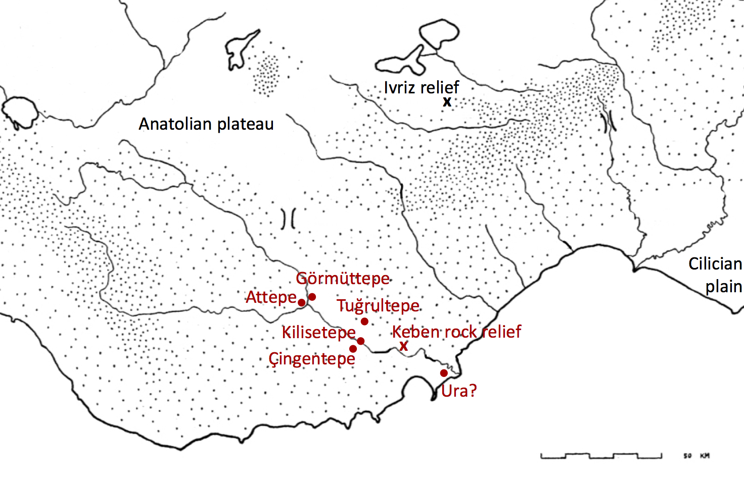
3§3 Inland in the Göksu valley, there was stability and continuity of occupation with previous periods, with the two alluvial plains characterized by the same basic settlement plan as they had been for much of the Bronze Age. The center of each plain was dominated by a pair of twin settlements, one on either side of the river, each located on a sizeable höyük mound due to their centuries-long occupation history. In the northern plain close to Mut, the twin höyüks are Attepe and Gömüttepe; in the southern plain close to Kışla, they are Kilisetepe and Çingentepe. Recent excavations at Kilisetepe have uncovered large scale storage facilities from the MIA levels of the site, suggesting that these settlements may have functioned as central nodes for the collection and storage of agricultural goods from the immediate surrounding area.[5] These central sites were not the only settlements in the valley however. The recent discovery of MIA material from Tuğrultepe, on the north-eastern fringe of the Kışla plain, demonstrates that smaller communities were also exploiting more marginal agricultural land.[6] This has implications for the size and dispersal of the valley’s population at this time.
3§4 The valley during this period seems to have been an important route for trade and communication, as implied by the imports found at Kilisetepe. These include Cypriote ceramics that must have come up the valley from the south,[7] as well as a Type XII.9 Phrygian fibula that must have come into the valley from the north.[8] The presence of the fibula is significant in that it is an elite item, valuable not only in its own right, but also representative of a central Anatolian visual language of power. Phrygian fibulae of this type were markers of status, and were conspicuously included on the Ivriz relief – a royal portrait of a local king from south-central Anatolia, just north-east of the Göksu valley.[9] High status textiles may also have been exchanged along similar trade routes, such as brightly-colored and finely pattern-woven textiles found in ninth century levels at Gordion.[10] It is possible that settlements in the Göksu valley may also have been engaged in the production of textiles in substantial quantities, given the evidence for weaving from these levels at Kilisetepe,[11] and the suitability of landscape around the fringes of the valley for herding sheep and goats.
3§5 The primary route for such trade and interaction would have been along the main north-south corridor through the valley from the plateau to the sea. Although traces of this road have not been found per se, remains have recently been documented of a Hellenistic and Roman road that passed directly under a Neo-Hittite rock relief near the village of Keben.[12] This relief itself, known as the Çolakkız (“crippled girl”), dates to the Iron Age, suggesting that this was also the road used during the MIA.
3§6 Contemporary documents suggest that the people of Rough Cilicia at this time were active players in the game of inter-regional politics. Texts from the Neo-Assyrian archives refer to the region as Hilakku, and in the ninth century describe King Pihirim of Hilakku allying with the kings of neighboring Cilician Plain, known in the Assyrian documents as Que, to attack the Neo-Assyrians in Syria.[13] When this campaign failed, it seems Hilakku fared somewhat better than Que, avoiding Neo-Assyrian reprisals because of the protection offered by their mountainous terrain.[14] The kings of Hilakku appear in the documents again at the very end of the eighth century, once more fighting against the Neo-Assyrians in an alliance of other states including Que but also the Muski (Phrygians).[15] The Neo-Assyrians once more defeated this coalition, and this time inflicted a terrible punishment on the people of Hilakku.[16]
3§7 Despite this show of strength, Neo-Assyrian control of the region does not seem to have been particularly stable, and Hilakku continued to be ‘unsubmissive’ well into the seventh and even the sixth centuries (for more on which, see below). The Neo-Assyrian documents suggest, if nothing else, that Rough Cilicia was the location for some kind of state or political entity: this was stable enough to have several settlements that might be called ‘cities’, some of which were fortified; strong enough to challenge Neo-Assyrian authority on several occasions, even after suffering defeats; and connected to its neighbors both to the east and south (Que and the Neo-Assyrians), and to the north and west (the Phrygians). Geographically, these texts make frequent reference to the inland or mountainous location of the Hilakku cities – it seems most likely that while some were located in the Göksu valley (perhaps at sites already identified), some of the fortified locations would likely have been in mountain passes and have therefore yet to be located. There are unfortunately no texts or inscriptions from the MIA in Rough Cilicia itself that might help to shed light on the issue. While we do have some inscriptions from various eighth century kings on the Cilician Plain,[17] unfortunately it does not seem that the rulers of Hilakku adopted their neighbors’ epigraphic habits.
The ‘After’: the Archaic period
4§1 In contrast to the mainstream Greek chronology which is based on events in the Aegean, for this region the Archaic period runs up until the arrival of the Persians, with the subsequent period being the Achaemenid Period (rather than the Classical). In the context of this paper then, the Archaic period is a relatively narrow span of time between the supposed establishment of culturally Greek communities on the coast and the conquest by Cyrus the Great (c.700–540 BCE).
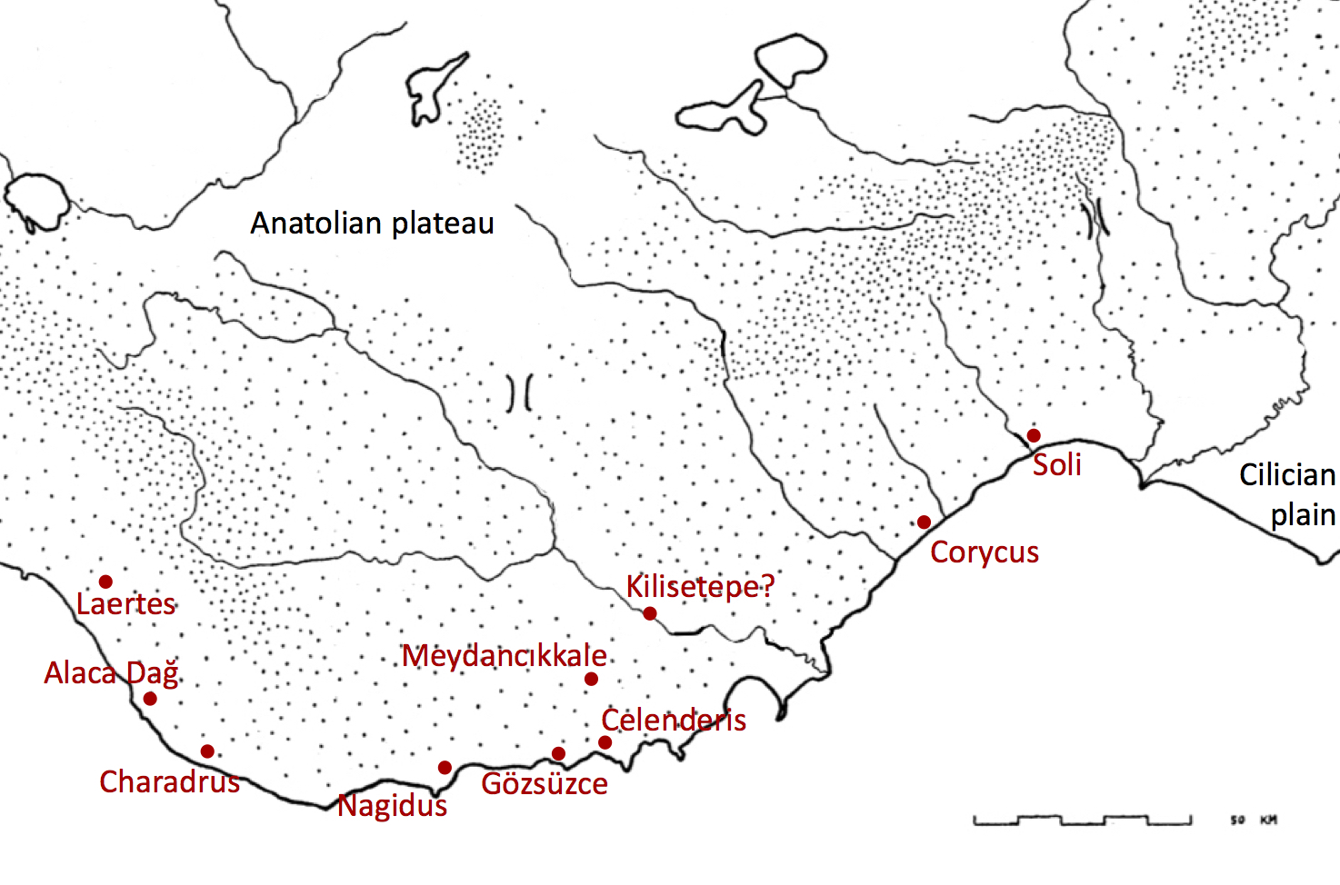
4§2 The seventh and sixth centuries seem to have seen a change in the settlement patterns of the coastal strip (Figure 2). Moving along the coast from east to west, evidence for occupation now appears at the sites of Soli, Celenderis, Gözsüzce, Nagidus, Charadrus, Alaca Dağ, and Laertes.[18] At most of these coastal settlements, forms of material culture have been found and social practices can be inferred which we can classify as ‘Greek’. At Soli, a new stone-built complex of rectangular buildings was constructed, and the ceramic assemblage of the seventh and sixth centuries includes imports from Miletus, Samos, Rhodes, Chios, and Corinth.[19] In addition, the site has yielded a number of architectural terracottas, demonstrating the presence at Soli of both architectural technologies and conventions of figural representation normally associated with the Aegean and Lydia.[20] Distinctly Greek artistic conventions are also found at Celenderis, where a pair of sixth century figured stelae likely marked the same monumental tomb,[21] and where a range of imported ceramics from Rhodes and Samos have also been found from both the seventh and sixth centuries.[22] The Archaic remains from Nagidus are less extensive, but include Samian imports.[23] A final site, Charadrus,[24] is mentioned in the sixth century writings of Hecataeus of Miletus, and therefore can be said to have existed in the Archaic period, even though no archaeological remains from this time have yet been discovered.
4§3 Although the settlements above listed were considered to be Greek poleis by the start of the Hellenistic period, it remains unclear whether we should classify them as Greek ‘colonies’ in the seventh and sixth centuries. At Celenderis, Soli, and Nagidus, the assemblages contain not only the Greek styles of material culture as mentioned above, but also objects from Cyprus and the Levant,[25] some of which imply cult practices linked to Cypriote or Levantine ritual.[26] At the site of Alaca Dağ, no imports were found at all – only local Cilician ceramics;[27] while at Gözsüzce only a Cypriote terracotta figurine was discovered and no ‘Greek’ material.[28] In absolute terms therefore, neither the quantity of available evidence nor its nature are sufficient to come to any conclusions as to the ethnic nature of the inhabitants of the coastal settlements, either individually or collectively. Indeed, the only named inhabitant of the coast that we can identify chose to write not in the Greek language, but in Phoenician. At the westernmost of our coastal sites, Laertes, a Phoenician inscription from the seventh century has been found, recording the exile of a member of one of the royal families of Que, who seems to have fled westwards after he was caught intriguing against the Neo-Assyrians.[29] The establishment and expansion of settlements on the coast was not, it seems, inextricably linked with ‘Greeks’. And yet, the dramatic changes seen on the coast did clearly come hand-in-hand with an increase in contacts with the Greek world, and the adoption of some Greek styles and practices.
4§4 The simultaneous changes that appear to occur in the settlement pattern of the Göksu valley are equally dramatic. There is no evidence for any occupation of the northern alluvial plain at this time, as both Attepe and Görmüttepe seem to have been abandoned. In the southern plain, Çingentepe and Tuğrultepe no longer seem to be inhabited, and the evidence from Kilisetepe is unclear. Specifically, while there are no levels that can be identified with certainty as belonging to this period, an occupation layer has been identified in one area of the mound which may potentially be of Archaic date.[30] If, once ceramic analysis is complete, this deposit can be dated to the Archaic period, it would suggest continued occupation of the site, and continuity in the production of textiles.
4§5 That this period constitutes such a dramatic gap in the archaeological record is remarkable. The problem may be partly disciplinary, due to our difficulty in identifying local ceramics from this time. And yet, a wide range of imported ceramics can be easily identified for the coast. Another potential explanation for the gap may be that construction work in later periods have destroyed the remains of Archaic occupation of the four main höyüks in the valley. This is possible given the extent of Late Roman and Byzantine occupation on all four mounds, but in this case we might expect that some unstratified ceramic material still would have survived. Overall, I would conclude that the valley was relatively sparsely populated in the Archaic period, with no major settlements in the central parts of the plains. This does not preclude, however, the existence of smaller settlements in the uplands, and perhaps a settlement pattern based on seasonal transhumance. This would, however, be extremely difficult to detect in the archaeological record.
4§6 The one inland site that can firmly be dated to the Archaic period is Meydancıkkale, located high on a steep mountain pass between Kilisetepe and Celenderis. The site is hard to access and heavily fortified, and continued to be used as a fort in the Achaemenid and Hellenistic periods. The site seems to have been established towards the end of the seventh century BCE,[31] and an Aramaic inscription from the sixth century identifies the ancient name of the site as Kiršu. The city of Kiršu is known from the Neo-Babylonian Chronicles, which record the continued attempts of Mesopotamian kings to subdue Rough Cilicia. In 557 BCE, the king Neriglissar launched a punitive raid against a local king, Appuašhu, whose mountain fortress was Kiršu.[32] The reasons for locating a stronghold in such a location are multiple – not only did it offer a defensible position in a relatively hard-to-access area; but its position in the hills could also have made it a center for logging and timber-collection, which would have been necessary for the maritime activities of the coastal cities.
Conclusion: colonization or transformation?
5§1 Rough Cilicia presents us with evidence for a dramatic change between the Middle Iron Age and the Archaic Period, involving a shift in population and settlement from the Göksu valley to the coast. The Göksu valley, which previously had been an important trade route and center for agricultural production and settlement, now seems to have lost its importance. Although there likely remained some inland occupation during the Archaic period, this seems to have been less focused on the valley and the north-south channel of communication it provided between the Anatolian plateau and the sea. Instead, the coastal cities were oriented primarily towards an east-west maritime route, forming a string of ports for easy travel along the coast between the Aegean and the Levant.
5§2 The change in settlement patterns has broader social and historical implications. Most obviously, it suggests a change in economic and political orientation, but it may perhaps also imply social and cultural changes for Rough Cilicia’s population. It is tempting to connect this transformation to the phenomenon known from other parts of the Mediterranean as Greek ‘colonization’. We might explain the change in settlement patterns by the arrival of ethnically Greek settlers and their establishment of new trading emporia on the coast, which may then have attracted economic and demographic resources from inland areas. We must be wary of jumping to any such conclusions however. The current evidence does indeed suggest an increased connectivity and/or receptivity to goods, styles, and practices associated with the Aegean, and does seem that new arrivals did come from the Aegean and settle in Rough Cilicia at this time. But the current evidence suggests that they lived in their new coastal cities alongside local Cilicians, and perhaps also Cypriots too. Indeed, the state of evidence is such that we cannot attribute the foundation of the new cities to any one group – locals, Aegean settlers, or settlers from elsewhere. Because of this, the term ‘Greek colony’ is not an accurate description for the cities of coastal Rough Cilicia during the Archaic period. The questions of what happened between the Archaic and Classical periods – during which transition these same cities came to identify themselves as explicitly ‘Greek’, and Greek social and cultural forms became dominant – is another paper entirely.
References
Antonaccio, C. 2007. “Colonization: Greece on the Move, 900–480.” The Cambridge Companion to Archaic Greece, ed. H.A. Shapiro, 201–224. Cambridge.
Ballard, M.W. 2012. “King Midas’ Textiles and His Golden Touch.” The Archaeology of Phrygian Gordion, Royal City of Midas, ed. C.B. Rose, 165–170. Philadelphia.
Bouthillier, C., C. Colantoni, S. Debruyne, C. Glatz, M. M. Hald, D. Heslop, E. Kozal, B. Miller, P. Popkin, N. Postgate, C. S. Steele, and A. Stone. 2014. “Further work at Kilise Tepe, 2007-2011: refining the Bronze to Iron Age transition.” Anatolian Studies 64:95–161.
Casabonne, O. 2005. “Quelques Remarques et Hypothèses sur Ura et la Cilicie Trachée.” Colloquium Anatolicum 4:67–81.
Davesne, A., A. Lemaire, and H. Lozachmeur. 1987. “Le site archéologique de Meydancikkale (Turquie); du royaume de Pirindu à la garnison ptolémaïque.” Comptes rendus des séances de l’Académie des Inscriptions de Belles-Lettres 131:359–383.
Doksanaltı, E.M., and R. Özgan. 2008. “Kilikia’dan arkaik devre ait iki kabartma üzerine düşünceler.” Anadolu 32:1–24.
Foxhall, L., P. Lazarus, K. Michelaki, J. Robb, D. Van Hove, and D. Yoon. 2007. “The changing landscapes of Bova Marina, Calabria.” Uplands of Ancient Sicily and Calabria. The Archaeology of Landscape Revisited, ed. M. Fitzjohn, 19–34. London.
Harmanşah, Ö. 2015. Place, Memory and Healing. An Archaeology of Anatolian Rock Monuments. New York.
Hawkins, D. 2000. Corpus of Hieroglyphic Luwian Inscriptions, Vol. 1. Berlin.
Heffron, Y., T.E. Şerifoğlu, C. Steele, and A. Stone. 2017. “Section 7.2: The J/K/L14 Sounding.” In Excavations at Kilise Tepe 2007-2012: The Late Bronze and Iron Ages, ed. J.N. Postgate. Cambridge. (available online at: https://www.repository.cam.ac.uk/handle/1810/264259)
Holtzman, S. Forthcoming. “A Patterned Textile from Gordion and Its Relation to 9th-century Phrygian Painted Pottery and Mosaics.”
Laflı, E. 2001a. “Ceramiche in Cilicia Tra XII e VI secolo a.C.” Quaderni friulani di archeologia 11: 155–191.
———. 2001b. “Das eisenzeitliche Kilikien:L Zue Geschichte und materiallen Kultur einer hurro-luwischen Kulturlandschaft im südlichen Kleinasien während der Eisenzeit (ca. 1200 bis 600 v. Chr.).” Archäologische Informationen 24.2:335–344.
———. 2001c. “Alaca Dağ: eine neue Fundstelle von späteisenzeitlicher Keramik im westlichen Rauhen Kilikien.” La Cilicie: Espaces et Pouvors Locaux (2emillénaire av. J.-C. – 4e siècle ap. J.-C.), ed. É. Jean, A.M. Dinçol, and S. Durugönül, 195–213. Paris.
Lipinski, E. 2004. Itineraria Pheonicia. Leiden.
Mac Sweeney, N. 2017. “Section 9: Artefacts from Kilise Tepe, 2007-2011.” Excavations at Kilise Tepe 2007-2012: The Late Bronze and Iron Ages, ed. J.N. Postgate. Cambridge. (available online at: https://www.repository.cam.ac.uk/handle/1810/264259)
Skinner, J.E. 2012. The Invention of Greek Ethnography. From Homer to Herodotus. Oxford.
Şerifoğlu, T.E., N. Mac Sweeney, and C. Colantoni. 2017. “Lower Göksu Archaeological Salvage Survey Project, the Fourth Season.” Anatolica 43:1–13.
Van Dommelen, P., and M. López-Bertran. 2013. “Hellenism as subaltern practice: rural cults in the Punic world.” The Hellenistic West. Rethinking the Ancient Mediterranean, ed. J.R.W. Prag and J. Crawley Quinn, 273–299. Cambridge.
Vlassopoulos, K. 2013. Greeks and Barbarians. Cambridge.
Yağcı, R. 2013. “Problematizing Greek Colonization in the Eastern Mediterranean in the Seventh and Sixth Centuries BC: the case of Soli.” Rough Cilicia. New Historical and Archaeological Approaches, eds M.C. Hoff and R.F. Townsend, 6–15. Oxford.
Zoroğlu, L. 1994. “Kelenderis’in İlk Çağ Tarihi Hakkında Notlar.” Türk Tarih Kongresi 11:437–448.
———. 2000. “Kelenderis Nekropolü.” Olba 3:115–133.
Zoroğlu, L., A. Çalik Ross, M. Tekocak, and S. Sağlan. 2005. “Kelenderis 2004 Yılı Kazısı.” Kazı Sonuçları Toplantısı 27.2:241–256.
[1] This includes much heated debate over the nature of these communities, and the extent to which the terminology of ‘colonization’ is appropriate in an ancient Greek context. For recent discussions with references, see Antonaccio 2007; Vlassopoulos 2013, 78–128.
[2] Foxhall et al 2007; Skinner 2012, 204–211.
[3] Van Dommelen and López-Bertran 2013.
[4] The ‘Merchants of Ura’ appear as active participants in the complex networks of trade that spanned the Near East and Eastern Mediterranean in the Late Bronze Age. For the debate over the location of Ura, see Casabonne 2005.
[5] Bouthillier et al 2014, 115, 117, and 119–122; Heffron, Şerifoğlu, Steele and Stone 2017, 107, 122, 126, 134–142.
[6] Şerifoğlu et al 2017, 4.
[7] Bouthillier et al 2014, 117.
[8] Mac Sweeney 2017, 33–34, no. 301.
[9] Hawkins 2000, 516–518, 526, 529–530 and plates 292–295, 300 and 304; for the Phrygian connection of the Ivriz relief, see Harmanşah 2015, 139.
[10] Brian Rose pers. comm.; Ballard 2012; Holzman forthcoming.
[11] Mac Sweeney 2017, 67–237.
[12] Şerifoğlu et al 2017, 6.
[13] RIMA 3: 10, 16–17.
[14] RIMA 3: 55, 58, 67–68.
[15] Sargon II, Display Inscription 55; Bull Inscription 92; Pavement Inscriptions 99.
[16] Sargon II, King Prism iv.69–90 (RINAP 3.0117)
[17] These inscriptions are in both Phoenician and Luwian, see Lipinski 2004, 116–128 for the kings Awarku and Wariyka, the dynasty of Mopsos/Muksas, and the inscriptions of Karatepe and Çineköy.
[18] In this list, I have only included sites where there is contemporary evidence from the seventh and sixth centuries – either in the form of archaeological remains, or references in literary texts from the sixth century itself. There are several other sites which have remains from the fifth and fourth centuries BCE (and of course later periods), and others still which are mentioned by literary texts from Hellenistic and Roman times, but I have not included them this does not constitute firm evidence for occupation in the Archaic period.
[19] Yağcı 2013, 9.
[20] Yağcı 2013, 10–13. I have not referred to these architectural terracottas as ‘Greek’ as the excavators of Soli do, because such terracottas are equally well known from Sardis in Lydia as they are from Corinth and mainland Greece. Literary references to the foundation of Soli include foundation by Achaeans and Rhodians from Lindos (Strabo 14.5.8), and an alternative claim from Argos (Pomponius Mela 1.71). Soli and Rhodes seem to have made strategic use of these stories later, during the negotiations that led to the Peace of Apamea in 189 BCE (Polybius 21.24.11; Livy 37.56.7). Another literary reference to the city’s early history suggested that Amphilochus was killed here (supposedly in the duel with Mopsos; Hesiod F279 MW = F215 Most = Strabo 14.5.17). The existence of Soli in the sixth century can also be inferred by it being mentioned by Hecataeus (BNJ 1 F268). Other later textual references to Soli include: Xen. An. 1.2.24; Ps-Scylax 102; Strabo 14.5.8 and 17; Eust. Comm, Dion. Per. 875; Lindian Chronicle BNJ 532 C33; Diog. Laert. 1.51; SEG 34 282; Arr. An. 2.5.5).
[21] Doksanaltı and Özgan 2008. Literary sources claim variously that Celenderis was founded by Sandocus, who came to Cilicia from Syria but was a descendant of the Athenian Cecrops, some seven generations removed (Ps-Apollodorus 3.14.3); or by Samians (Pomponius Mela 1.77; Aelius Herodianus 3.2 925.7). Other later textual references to Celenderis include: Ps-Scylax 102; Strabo 14.5.3; IG I3 71.146.
[22] For the Archaic Greek ceramics at Celenderis, see Zoroğlu et al 2004, 242 for the acropolis; and for the necropolis: Zoroğlu 1994, 37–38 and Zoroğlu 2000, 124 and 132.
[23] Hecataeus BNJ 1 F266, who claims that the city was named after the helmsman Nagis (who is unattested elsewhere). An alternative account of the city’s foundation claims it was founded by Samians (Pomponius Mels 1.77). Later textual references to Nagidus include: Ps-Scylax 102; Strabo 14.6.3; SEG 39 1426). For the Samian ceramics, see Laflı 2001a, 172.
[24] Hecataeus BNJ 1 F267 mentions the Charadrus river. Later textual references to Charadrus include: Ps-Scylax 102; Strabo 14.5.3.
[25] Soli: Yağcı 2013, 7. Celenderis: Laflı 2001a, 161. Nagidus: Laflı 2001a, 162.
[26] E.g. the depiction of an Astarte-Wanassa figure on an amphora from Soli: Yağcı 2013, 7; Cypriote figurines from Nagidus: Laflı 2001b, 339.
[27] Laflı 2001c.
[28] Zoroğlu 1994, 304.
[29] Lipinski 2004, 128–129.
[30] The N15 loomweight deposit. See Mac Sweeney 2017, 18–22.
[31] Davesne et al 1987, 350.
[32] Davesne et al 1987, 372–377.