Citation with persistent identifier:
Coutsinas, Nadia. “The Establishment of the City-States of Eastern Crete from the Archaic to the Roman Period.” CHS Research Bulletin 2, no. 1 (2013). http://nrs.harvard.edu/urn-3:hlnc.essay:CoutsinasN.The_Establishment_of_the_City-States_of_Eastern_Crete.2013
§1 The island of Crete is both the southernmost and the largest island in Greece. So, unlike the other Greek islands, it was home to dozens of cities, which all had to contend for enough land to survive. Inevitably, the urban centers fought for their survival and the Cretan wars of the Hellenistic period are now famous with the history of Crete, from the Archaic to the Hellenistic period being well documented[1]. Recent studies focus on either the birth of the Cretan polis[2] or on the Roman period[3].
§2 One thing that has become apparent is the evolution of the political map of Crete. The number of cities dropped from 57, in Classical times[4], to 27 in the Roman period[5], and then to 22 in the Byzantine period[6]. Crete’s history is comprised of conquests, disappearances, and appropriations. The territories evolve attesting to the fact that the island simply could not sustain the great number of the Classical poleis. What interests me is trying to understand what elements make some cities grow and survive into the Hellenistic and Roman periods while others eventually are conquered and disappear from the political map. I contend that geography is a key element for understanding the political evolution of the cities, but it is somehow neglected by historians and archaeologists. In this paper I am going to focus on Eastern Crete and show the evolution from the Archaic to the Roman period. I would like to show how geographical elements complete and complement archaeological and historical evidence and can help to answer some questions.
Geographical Presentation
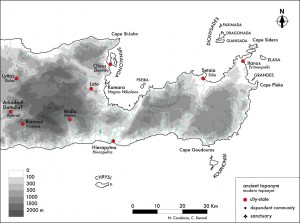
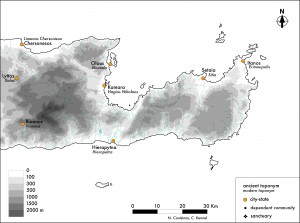
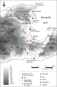
§3 The most prominent feature of the Cretan landscape is the mountains, to such a degree that the island has been described as a mountain in the sea (Figure 1). In the east, the highest ranges are that of Lassithi (1564m to the north and 2148m to the south). Farther east, the mountains of Sitia are of lesser height; the Thryptis reaching 1476m. As a result, the landscape of Crete is highly divided, which has an important impact on the development, the survival and the expansion of each city.
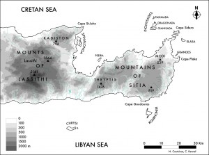
§4 The mountains occupy more than half of the island while the fertile plains only account for 5%, and that mostly along the coasts. The main plains in eastern Crete are those of (from east to west): Itanos, Sitia, Hierapytna, Lato, Chersonesos. It is not a surprise to learn that they host the most powerful cities (except for Chersonesos which is less important in the Hellenistic period). The high plateau of Lassithi is a specific historic case in that it never contained a city-state (and is more related to Lyttos to the west).
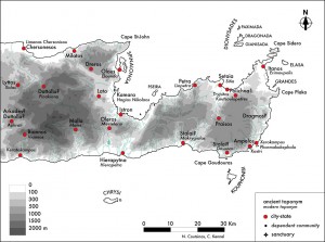
§5 Specific to the eastern Crete are three north-south corridors (Figure 2): the one linking the bay of Sitia to the south coast (along which is Praisos), the one linking the bay of Mirabello to the south coast (at the end of which is Hierapytna – it is called the Hierapetra isthmus), and the one linking the bay of Mirabello to the north coast (along which is Dreros). It is interesting to notice that the only two inland cities east of the Lassithi, Praisos and Dreros, are situated along these corridors.
The Cretan City-States
Κρήτην ἑκατόμπολιν
§6 Since Homer, Crete is said to have held a hundred cities. In the Iliad[7] the island is referred to as ἑκατόμπολις. The epithet is used only once, but the concept held a lasting effect; in the Roman period, a funerary inscription of a gladiator in Gortyn calls him ἑκατoμπολῖται[8]. In the Odyssey, Crete has only ninety cities: “there is a land called Crete in the midst of the wine-dark sea, a fair rich land, surrounded by water, and there are many men in it, past counting, and ninety cities”[9] (ἐννήκοντα πόληες, XIX, 174.).
§7 If the tally of one hundred constitutes a poetic approximation indicating a great number, ninety seems to refer to something real. This difference has been commented on since antiquity, by authors such as Strabo[10]. Whatever the explanation, one thing is notable – the numbers given by Homer have always been considered exact by commentators since antiquity.
§8 The interest in the one-hundred citied Crete revived during the Venetian period (1204-1645) with the first travelers, but also the first censi (counting of population). In 1577, Fr. Barozzi writes the first catalogue of the hundred antique cities of Crete[11]. The interesting point is that the more modern scholars, in trying to compile a list of Cretan cities, always adhered (consciously or not) to the Homeric tradition and made lists of a hundred toponyms: 102 for P. Faure[12], 100 for St. Spanakis[13] (both in the 1950’s). And, perhaps even more interestingly, modern research on the linear B archives of Knossos has also brought to light a hundred toponyms[14], when, in fact nearly two hundred Cretan toponyms have been recorded by modern scholarship[15]. Only 57 survive to enjoy the status of city-state[16].
How do we know the names of the Cretan cities?
§9 Ancient Cretan city names have been recorded through centuries. The names have been saved through inscriptions (treaties between Cretan cities[17], or with external powers, like the treaty with Eumenes II of Pergamon and 32 Cretan cities in 183 B.C.[18]), literature[19], ancient geographers[20] or on coins[21]. In addition, the archaeological remains of many cities, some of them impressive, have always been visible. Matching the ancient names with the archaeological remains has presented a challenge for modern scholars, but many of the ancient Cretan cities have been pin-pointed. The written sources have preserved 80 city-ethnicities or toponyms while the remains of 20 Archaic or Classical settlements cannot be convincingly linked to the written sources and remain unnamed[22].
Distribution of the City-States
§10 The territory of a city is, of course, essential to its survival. Due to the great size of Crete, the cities are distributed differently throughout the island. They can be divided into inland cities and coastal cities.
§11 Concerning the distribution of the cities, eastern Crete is different from the rest of the island (figure 2). While most of the Cretan cities are situated inland rather than on the coast (where they can more easily be attacked)[23], in eastern Crete (from the Hierapetra isthmus eastwards), the inland plains are too small to allow for the development of a city and the centers are all distributed along the coast, with the notable exception of Praisos. Around the Mirabello, however, the situation is more “normal” as most cities here are situated inland.
§12 So we can already distinguish distinct regional patterns in eastern Crete: the extreme east (with the main cities of Itanos and Praisos), the Mirabello (with the main cities of Hierapytna and Lato) and the Lassithi (with the main city of Lyttos)[24].
The Territory of the City-States
§13 Depending on its geographical situation, each city has a different territory, but they nevertheless share similarities. Each territory is composed of multiple zones permitting multiple exploitation, thus complementary economic activities, allowing the city to meet most of its basic needs. The traditional opposition between the ager, the cultivated part of the territory, and the saltus, waste areas, does not necessarily correspond to an opposition between plains and mountains. In Crete, the scarcity of plains pushes the farming of the different parts of the territory to its maximum[25]. Firstly, there is the arable land, which is very limited, and located in the plains, plateaux and valleys. The hills that surround the arable plains are used for breeding livestock and for the cultivation of vines and fruit trees (olives, figs and almonds). Finally, the mountains occupy the most important place in the territory. They are arid and deserted only at the highest altitude and so they can be utilized in many different ways: terraced agriculture, pastoralism and specialized activities (pertaining to weaving and leather work), logging, beekeeping and the collection of wild herbs.
§14 This can be linked to Aristotle’s definition of autarky: “the self-sufficient land is that which bears every sort of produce, for self-sufficiency means having a supply of everything and lacking nothing”[26]:
δῆλον ὅτι τὴν αὐταρκεστάτην πᾶς τις ἂν ἐπαινέσειεν (τοιαύτην δ᾽ ἀναγκαῖον εἶναι τὴν παντοφόρον· τὸ γὰρ πάντα ὑπάρχειν καὶ δεῖσθαι μηθενὸς αὔταρκες)·
§15 The dimension of a Greek city-state is theoretically limited. Aristotle says that “it must be able to be taken in one view”, and this to facilitate military protection[27]. This human imprint in the optimum scale of a territory became apparent in studies conducted by the Copenhagen Polis Centre:
Essentially, a city-state’s territory is the immediate hinterland of its urban centre, and a city-state which extends its frontiers beyond its immediate hinterland begins to lose one of its characteristics. Given the simple means of transportation in former times, and given the fact that a city-state is a community whose members are in close contact with one another, the maximum extent of the immediate hinterland can, ideally, be fixed at one day’s march from the urban centre = c.30 km. The inference is that the territory of a city-state may cover c.3000 km2 max.[28]
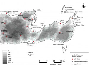
§16 But this theoretical maximum size is, however, much higher than what is observed in the field, especially in Crete. In the vast majority of cases, it was possible to make a round trip between the town and the border area in the same day. For Crete, the authors of the Inventory[29] make a quick calculation: having said that there were 49 contemporary cities in Crete, and the island having 8200km2, the average territory of a Cretan city was of 167km2. It is true that nearly all the Cretan cities have a territory easily viewed by eye (Figure 3) (at least in terms of its early evolution, before the political evolution of their territory).
Change in the Establishment of Settlements Throughout the Centuries
§17 Before the historic period and the establishment of the Greek cities, Crete has known many systems of establishment.
§18 In the Minoan period, the main settlements were situated on plains or on the coast. In eastern Crete there are the palace of Zakros, located on the eastern coast, and the palace of Malia on the Chersonesos bay[30].
§19 During the Late Bronze Age and the Early Iron Age, Cretans abandoned coastal sites and chose acropoleis sites (effectively high towns), that were naturally defensible. But these sites could only accommodate a small population. Around the Mirabello there are the sites of Kavousi, Vrokastro, Anavlochos (Figure 9).
§20 Then, from the 7th century BC onwards, these sites became progressively abandoned and the population became concentrated in new urban centers, which became the city-states. The population of Vrokastro moved down to Istron and Oleros while the population of Anavlochos relocated to Milatos and Dreros.
Preferred Locations for Urban Centers
§21 The sites chosen for Greek cities had enough space for the development of the community. In this they differ from the “defensible sites” of the Early Iron Age (that were abandoned precisely because of this lack of space to develop)[31].
§22 Cretans seem to have had a preference for a particular kind of site: medium altitude hills (generally situated in the zone between 300 and 500m), from where both arable lands and often the harbor could be seen. They very often chose sites with a double hill (often featuring a saddle).
Evolution of the Political Map of Eastern Crete
§23 I wish now to examine the evolution of the territory of the four main poleis of eastern Crete (lying east of the Lassithi mountains) in further detail: Itanos, Praisos, Hierapytna and Lato. As a preamble I will briefly outline the main developments of the region:
- In the 4th century BC (Figure 2), there were numerous independent cities. Along the eastern seaboard: on the northern coast, Petra, Setaia and Polichna; on the southern coast, Ampelos and Stalai. Around the Mirabello: Olous and Istro on the coast, Dreros, Lato, Oleros inland.
- At the beginning of the 3rd century BC (Figure 4) Praisos had already taken control of most of the cities to the east, while Hierapytna also expanded its territory.
- But Praisos was conquered by Hierapytna in the middle of the 2nd century BC (Figure 5). To the east, only Itanos remained (although Setaia may have regained its independence then). Around the Mirabello, only Lato and Olous remained, Dreros being conquered by Lyttos; Oleros and Istro either by Lato or Hierapytna.
- In the Roman period only coastal cities remain independent (Figure 6). The development of coastal sites is characteristic of the Roman period. This can be explained by the end of piracy and the development of trade on a larger scale. But for Lato this tendency had already appeared at the end of the Hellenistic period, as we will see later.
Itanos
§24 The territory of Itanos remained much the same over the course of its history as the city did not need to expand inland as it already had a hinterland big enough to sustain the inhabitants of the city (Figure 7). Furthermore, as a harbor situated at the easternmost part of Crete, Itanos was more easily connected to the eastern Mediterranean than to the rest of Crete[32]. The city has always been in contact with Africa and had close political and economic contacts with Egypt from the Hellenistic period onwards[33].
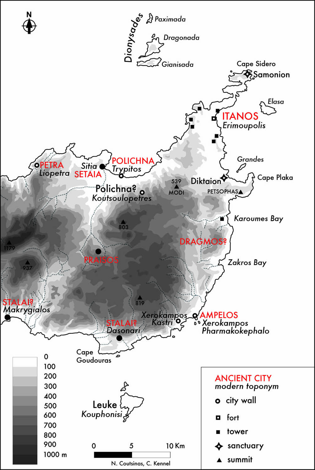
§25 After the conquest of Praisos by Hierapytna in the middle of the 2nd century BC (145 or 140 B.C.), the city became a neighbor of Itanos. A conflict broke out then between the two cities over the administration of the sanctuary of Zeus Diktaios (situated at modern Palaikastro) and the control over the island of Leuke, both claimed by Itanos and disputed by Hierapytna[34]. The dispute was finally settled in 112 B.C. with an arbitration of Magnesia on the Maeander. Thanks to this particular conflict, we have the complete description of the borders of Itanos, recalled in the final judgment (Figure 8)[35].
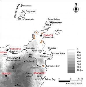
§26 It is only from this text that we know of the city of Dragmos. It shared a border with Itanos but was conquered at some point by Praisos[36]. Two locations have been suggested. One is Koutsoulopetres Kastri[37], south of the bay of Sitia, and the other somewhere on the east coast of Crete. Koutsoulopetres is the site of a fortified town which would provide a fitting setting for the urban center of an independent city. Unfortunately, it seems from the border delineation that Dragmos was situated on the southeast border of Itanos, so it could not be positioned at Koutsoulopetres. An east coast location would be more suitable[38], perhaps near Epano Zakros[39]. The problem is that only scanty Geometric and Roman remains have been found there and we are still looking for Dragmos.
§27 I think that Koutsoulopetres Kastri is the inland site of Polichna, whose harbor is at Trypitos (Figure 7). It represents a good example of an interesting Cretan urban characteristic: the double-sited city[40]. This goes beyond the favored double-hill sites characteristic of other the Cretan poleis. In these specific cases, the sites are clearly separated, but occupied in parallel; one being a defensible site (up on a hill), usually occupied in the first place, and the other generally a harbor, occupied in a second phase. The fortified Hellenistic settlement on the Trypitos peninsula in the Sitia bay has been securely identified with the city of Polichna[41]. South of it, on the hills surrounding the Sitia bay are the remains of the fortified settlement at Koutsoulopetres Kastri. Its identification with Dragmos does not fit with the border inscription that we have, but if it were Dragmos, this would mean that there would be three independent cities sharing the plain of Sitia (Setaia, Dragmos, Polichna). This does not make much sense (in term of survival, as the Sitia plain cannot support the population of three cities). That is why I think we should see Trypitos and Koutsoulopetres Kastri as the two sites of Polichna: the acropolis and the harbor[42].
Praisos
§28 Praisos presents a very different situation from that of Itanos. Situated inland, without an arable plain, one of its prerequisites for survival would be to access the sea, which, in turn, determined a policy of conquest and expansion (Figure 7). From the 4th century BC onwards, Praisos demonstrates a policy of territorial expansion that would change the territorial organization of Eastern Crete. We know that in the 3rd century BC, Praisos controlled Setaia, Stalai, Dragmos, Ampelos and possibly the island of Leukè, which was initially a possession of Itanos[43].
§29 Like Dragmos, the exact location of Stalai remains unknown. Two locations have been suggested: Dasonari, on Cape Goudouras[44], or Makrygialos, farther west[45]. Dasonari seems a more logical siting as it positioned on the coast just north, and facing the islet of Kouphonisi (this port still provides the shortest boat trip to the islet with the modern harbor situated east of the cape). We know from a 3rd century BC inscription that Praisos then controlled both Setaia and Stalai, together with the islands of the Stalitai, among which was probably Leukè (modern Kouphonisi)[46]. A siting at Makrygialos would constitute an exact counterbalance to Sitia, to the north, along the south coast; where both sites would effectively seal the north-east/south-west corridor (controlled by Praisos at its midpoint) that divides eastern Crete.
§30 Already in the middle of the 4th century BC the Pseudo-Skylax tells us that Praisos governs both sides[47]. West of the Lassithi, the same remark is made for Lyttos which is similarly situated inland, yet extends her territorial reach to gain access to the sea[48].
Hierapytna
§31 In the south-west of the eastern region of the island (Figure 9), the city of Hierapytna appears only in the 4th century BC and it quickly expands to become prominent politically. But the expansionism of Hierapytna is different from that of Praisos as it is already a coastal city with full access to the sea. It is also strategically well-placed at a point where the island of Crete narrows (with a width of only 14km at this point, while in the center the island extends to 60km in width). So securing control over the isthmus also extends to that of the maritime traffic along both coasts and overland transit traffic between the Cretan sea and the Libyan sea[49]. We have evidence for the progressive expansion of Hierapytna in the 2nd century BC along the isthmus to the north, when it takes control of the harbor of Tholos[50] and the islet of Mochlos[51].
§32 Hierapytna’s political expansion is particularly impressive as it enters the political arena at a relatively late stage but goes on to become the most important polis in eastern Crete and the greatest Cretan city after Knossos and Gortyn. We do not know exactly when Hierapytna was founded[52]; certainly in the 4th century BC, and even by the 3rd, it is still of minor importance. But we know from Strabo that at some point there was a synoikismos with Larissa[53]. This city has not yet been located and many of the archaic sites around Hierapytna have been suggested[54].
Lato
§33 The city of Lato is situated in the main plain of the Mirabello region, west of the eponymous gulf. Its territory did not have the possibility for expansion and its main development was the relocation of its urban center to the coast. In the 2nd century BC, the population of Lato abandoned its inland location to settle at their harbor at Kamara. This should not be interpreted exclusively as a “descent to the sea”, as some other urban centers on the plain shifted, from higher, somewhat isolated, positions to sitings nearer to trade routes, which remained inland (like Kantanos in the Selino mountains and Arkades in the Messara).
§34 As for Itanos, the city’s territorial borders are preserved, and can be traced, in the inscriptions of Lato pertaining to a conflict between two neighboring cities (Figure 10)[55]. To the west of the Gulf of Mirabello, Lato was the dominant city, but between 116 and 110 BC, a conflict breaks out between Lato and Olous, again over the administration of a sanctuary and its territory, and over the possession of the islet of Pyrrha. The intervention of Knossos in 115 BC (in favor of Lato) does not resolve the issue and, as in the case of the Itanos-Hierapytna conflict, the Romans were called in for arbitration. They affirm the Knossian verdict in supporting Lato.
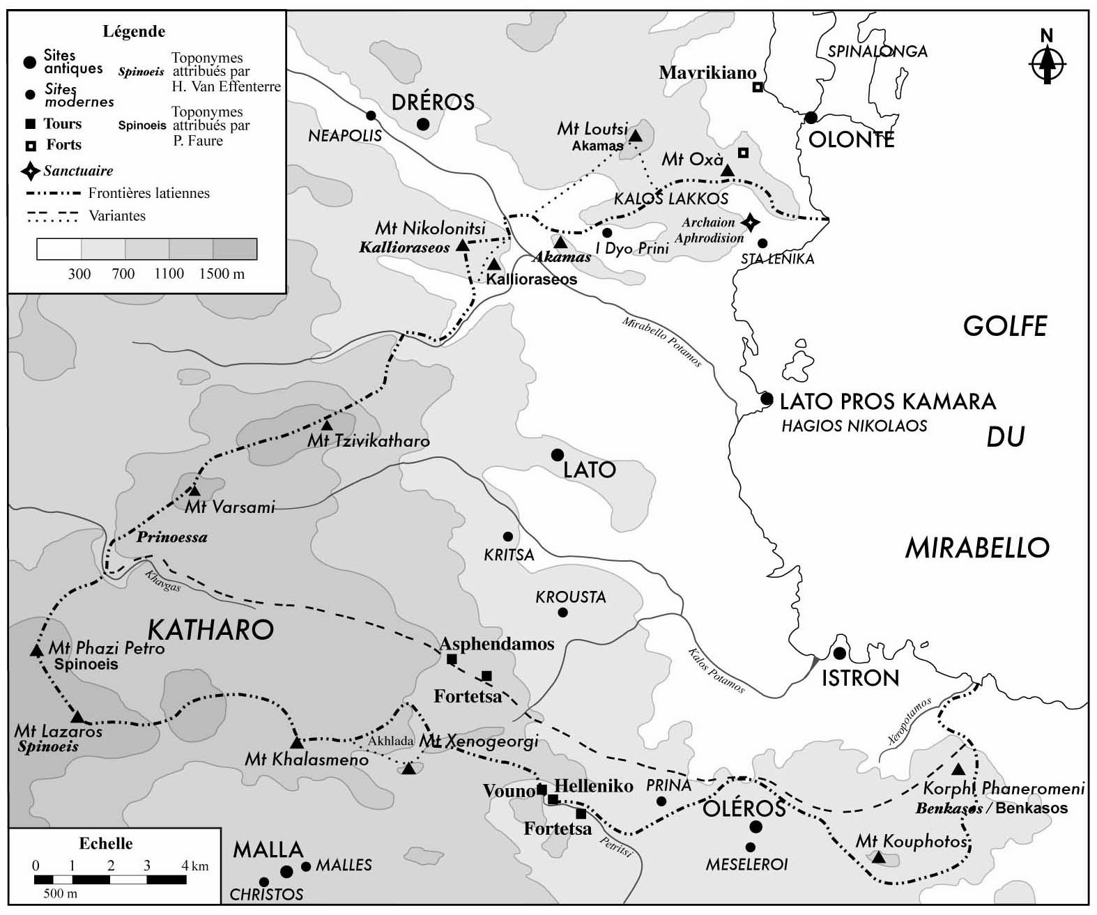
§35 The borders of Greek cities often informed by dominant geographical features in the landscape. Even if the ancient toponyms have disappeared, the geographical elements are still visible in the landscape and can often remain as prominent landmarks. It is interesting to see that the two plans drawn independently by P. Faure and H. Van Effenterre for Lato’s borders are quite similar. Moreover, archaeological work of the last century included both the discovery and excavation of one of the sanctuaries mentioned in the border description (ἀρχαῖον Ἀφροδίσιον)[56], while several forts discovered in the southern hills have been interpreted by H. Van Effenterre as border forts[57].
Conclusion
§36 In conclusion, I contend that the key to understanding the location and extent of many Cretan poleis lies in thorough geographical and topographical studies pertaining to the establishment and development of each city. These results must then be read against a backdrop of the political and economic knowledge for each center. I would hope that an overarching study of the establishment of the Greek city-state in Crete, combining topographical, archaeological and historical data, will further elucidate the dynamics driving, and in some cases impeding, ancient city planning.
Bibliography
IC I: Margherita Guarducci, Inscriptiones Creticæ – Opera et Consilio Friderici Halbherr Collectæ I Tituli Cretæ mediæ præter Gortynios, R. Istituto di archeologia e storia dell’arte, La Libreria dello Stato, Rome, 1935.
IC III: Margherita Guarducci, Inscriptiones Creticæ – Opera et Consilio Friderici Halbherr Collectæ III Tituli Cretæ orientalis, R. Istituto di archeologia e storia dell’arte, La Libreria dello Stato, Rome, 1942.
IC IV: Margherita Guarducci, Inscriptiones Creticæ – Opera et Consilio Friderici Halbherr Collectæ IV Tituli Gortynii, R. Istituto di archeologia e storia dell’arte, La Libreria dello Stato, Rome, 1950.
Angelakis, E. 1935. Σητειακά – ήτοι – Συμβολή εις την ιστορίαν της Σητείας από των αρχαιοτάτων χρόνων μέχρι των καθ’ημας – Τόμος Α’, Athens.
Barozzi, F. 2004. Descrittione dell’isola di Creta (Περιγραφή της Κρήτης) (1577/8), Mία γεωγραφική και αρχαιολογική περιγραφή της Κρήτης στα χρόνια της Αναγέννησης, εισαγωγή, έκδοση κειμένου, σχόλια και απόδοση στα ελληνικά Στέφανος Κακλαμάνης, Βενετικές πηγές της Κρητικής ιστορίας 3, Heraklion.
Bennet, J. 1985. “The Structure of the Linear B administration at Knossos.” American Journal of Archaeology 89:193-211.
Bougrat, M. 1966-1967. Monographie de la cité double de Lato, Diplôme (D.E.S.) sous la direction de M. Van Effenterre.
Bousquet, J. 1938. “Le temple d’Aphrodite et d’Arès à Sta Lenikà (Crète orientale).” Bulletin de Correspondance Hellénique 62:386-408.
Chaniotis, A. 1996. Die Verträge zwischen kretischen Poleis in der hellenistischen Zeit, Heidelberger Althistorische Beiträge und Epigraphische Studien 24, Stuttgart.
———. 1999. “Milking the Mountains: Economic Activities on the Cretan Uplands in the Classical and Hellenistic Period.” In From Minoan Farmers to Roman Traders, Sidelights on the Economy of Ancient Crete, Heidelberger Althistorische Beiträge und Epigraphische Studien 29, ed. Angelos Chaniotis, 181-220.
Counillon, P. 2001. “La description de la Crète dans le Périple du Ps. Skylax.” Revue des Études Anciennes 103:381-394.
Coutsinas, N. 2010. “Η άμυνα της Ιτάνου (άστυ και χώρα) και οι οχυρωμένες πόλεις της κλασικής και ελληνιστικής περιόδου στην Ανατολική Κρήτη”, in Μιχάλης Ανδριανάκης, Ίρις Τζαχίλη (επιμ.), Αρχαιολογικό Έργο Κρήτης 1, Πρακτικά της 1ης Συνάντησης, Ρέθυμνο, 28-30 Νοεμβρίου 2008, Rethymnon, 188-199.
———. 2011. “Territoire et frontières des cités crétoises hellénistiques. L’exemple de Latô.” In Archéologie du territoire, de l’Égée au Sahara, Cahiers archéologiques de Paris I, 2, Paris, ed. R. Treuil and G. Kourtessi-Philippakis, 253-263.
———. 2013. Défenses crétoises. Fortifications urbaines et défense du territoire en Crète aux époques classique et hellénistique, Cahiers archéologiques de Paris I, 3, Paris.
Faure, P. 1959. “La Crète aux cent villes.” Κρητικά Χρονικά 13:171-217.
———. 1960a. “La Crète aux cent villes.” Bulletin de l’Association Guillaume Budé: 228-249.
———. 1960b. “Nouvelles recherches de spéléologie et de topographie crétoises.” Bulletin de Correspondance Hellénique 84:189-220.
———. 1963. “Nouvelles localisations de villes crétoises.” Κρητικά Χρονικά 17:16-26.
———. 1967. “Aux frontières de l’État de Lato : 50 toponymes.” In Europa – Studien zur geschichte und epigraphik der frühen Aegaeis – Festschrift für Ernst Grumach, ed. William C. Brice, 94-112.
Guizzi, F. 2001. Hierapytna, storia di una polis cretese dalla fondazione alla conquista romana, Atti della Accademia nazionale dei Lincei, Classe di scienze morali storiche e filologiche, Memorie Serie 9, volume 13, fasciculo 3, Rome.
Guizzi, F., and V. E. Stefanaki. 2011. “Le synœcisme de Larisa par Hiérapytna en Crète orientale. Essai de mise en perspective d’après les nouvelles données archéologiques.” In Πεπραγμάνα τοῦ Ι᾽ Διεθνοῦς Κρητολογικοῦ Συνεδρίου (Χανιά, 1-8 Ὀκτωβρίου 2006), A4, Chania, 273-288.
Haggis, D. C. 1996. “The Port of Tholos in Eastern Crete and the role of a Roman Horreum along the Egyptian ‘Corn Route’.” Oxford Journal of Archaeology 15.2:183-209.
Hansen, M. H., ed. 2000. A Comparative Study of Thirty City-State Cultures, An Investigation Conducted by the Copenhagen Polis Centre, Historisk-Filosofiske Skrifter 21, Det Kongelige Danske Videnskabernes Selskab (The Royal Danish Academy of Science and Letters), Copenhagen.
Hansen, M. H., and Th. H. Nielsen, eds. 2004. An Inventory of Archaic and Classical Poleis. An Investigation Conducted by The Copenhagen Polis Centre for the Danish National Research Foundation. Oxford.
Harrison, G. W. M. 1993. The Romans and Crete. Amsterdam.
Hayden, B. J., ed. 2004. Reports on the Vrokastro Area, Eastern Crete II: The Settlement History of the Vrokastro Area and Related Studies, University Museum Monograph 119, Philadelphia.
Honigmann, E. 1939. Le Synekdèmos d’Hiérokles. Et L’opuscule géographique de Georges de Chypre, Bruxelles.
Kelly, A. 2012. “The Cretan Slinger at War: a weighty exchange.” Annual of the British School at Athens, 273-311.
Le Rider, G. 1966. Monnaies crétoises du Ve au Ier s. av. J.-C., Études crétoises XV, Université de Paris, Faculté des Lettres et Sciences humaines, Paris.
Livadiotti, M., and I. Simiakaki, eds. 2004. Creta romana e protobizantina. Atti del congresso internazionale (Iraklion, 23-30 settembre 2000), Bottega d’Erasmo, Padova.
Nowicki, K. 2000. Defensible sites in Crete ~ 1200-800 BC (LM III B/III C through early geometric), Aegaeum 21, Belgium.
———. 2002. “The End of the Neolithic in Crete.” Aegean Archaeology 6:7-72.
Panagiotakis, N. M., ed. 1987. Κρήτη: Ἱστορία καὶ πολιτισμός, Crete.
Papadakis, N. P. 1988. “Τρυπητός Σητείας”, Αρχαιολογικόν Δελτίον 43, Β᾽2 Χρονικά, 561-563.
———. 1989. Σητεία. Η πατρίδα του Μύσωνα και του Κορνάρου. Οδηγός για την ιστορία, αρχαιολογία, πολιτισμό της, Sitia.
———. 1994. “Τρυπητός Σητείας”, Αρχαιολογικόν Δελτίον 49 (1994) [1999], Β᾽2 Χρονικά, 746-747.
———. 1995. “ Άγνωστα νομίσματα μιας νέας αυτόνομης κρητικής πόλης στη Σητεία.” In Πεπραγμάνα τοῦ Ζ᾽ Διεθνοῦς Κρητολογικοῦ Συνεδρίου (Ρέθυμνο, 26-30 Αὐγούστου 1991), A2, Rethymnon, 741-744.
Perlman, P. 1995. “Invocatio and Imprecatio: The Hymn to the Greatest Kouros from Palaikastro and the Oath in Ancient Crete.” Journal of Hellenic Studies 115:161-167.
———. 1996. “Πόλις Ὑπήκοος. The Dependent Polis and Crete.” In Introduction to an Inventory of Poleis, Symposium, August, 23-26 1995, CPCActs 3, Historisk-Filosofiske Meddelelser 74, Copenhagen, ed. Mogens Herman Hansen, 233-287.
———. 2004. “Crete.” In An Inventory of Archaic and Classical Poleis. An Investigation Conducted by The Copenhagen Polis Centre for the Danish National Research Foundation, ed. Mogens Herman Hansen and Thomas Heine Nielsen, 1144-1195. Oxford.
Pharaklas, N. 1998. Οι επικράτεις των αρχαίων πόλεων της Κρήτης, Ρίθυμνα 6, University of Crete, Rethymnon.
Rizza, G., ed. 2011. Identità Culturale, Etnicità, Processi di Trasformazione a Creta fra Dark Age e Arcaismo. Per i cento anni dello scavo di Priniàs 1906-2006, Convegno di Studi (Atene 9-12 Novembre 2006), Università di Catania – Centro Di Archeologia Cretese, Palermo.
Sanders, I. F. 1982. Roman Crete, An Archaeological Survey and Gazetteer of late Hellenistic, Roman and early Byzantine Crete. England.
Schlager, N. 1991. Archäologische Geländerprospektion Südostkreta. Erste Ergebnisse, Berichte und Materialen des Österreichischen Archäologischen Institut 2, Vienna.
Spanakis, S. G. 1957. “ Ἀνέκδοτος κατάλογος τῶν 100 πόλεων τῆς Κρήτης”, Κρητικά Χρονικά 11:277-301.
Spratt, T. A. B. 1861. Sailing Directions for the Island of Candia or Crete, Printed for the Hydrographic Office, Admiralty, London.
———. 1865. Travels and Researches in Crete. London.
Spyridakis, S. 1970. Ptolemaic Itanos and Hellenistic Crete. University of California Press, Berkley, Los Angeles, London.
———. 1985. “Οἱ Πτολεμαῖοι καὶ ἡ Κρήτη.” Αριάδνη 3:5-49.
———. 1989. “ Ἡ ἀρχαία Πραισός.” Αμάλθεια 20 (vol. 78-79):97-112.
Stavrakis, N. 1890. Στατιστική του πληθυσμού της Κρήτης, μετά διαφόρων γεωγραφικών, ιστορικών, αρχαιολογικών κλπ. ειδήσεων περί της νήσου, Athens.
Van Effenterre, H. 1942. “Querelles crétoises.” Revue des Études Anciennes 44:31-51.
———. 1948. La Crète et le monde grec, de Platon à Polybe, BEFAR 163. Paris.
Van Effenterre, H., and M. Bougrat. 1969. “Les frontières de Lato.” Κρητικά Χρονικά 21:9-53.
Vokotopoulos, L. 2000. “Οχυρές θέσεις της Νεολιθηκής και Πρωτομινωϊκής Ι στην περιοχή της Ζάκρου.” In Πεπραγμάνα τοῦ Η᾽ Διεθνοῦς Κρητολογικοῦ Συνεδρίου (Ἡράκλειο, 9-14 Σεπτεμβρίου 1996), A1, Heraklion, 129-146.
Wallace, S. A. 2010. Ancient Crete: from successful collapse to democracy’s alternatives, 12th-5th centuries BC. Cambridge, New York.
Willetts, R. F. 1965. Ancient Crete: A Social History, From Early Times until the Roman Occupation, Routledge and Kegan Paul, London, Toronto.
[1] We can mention the following general studies: Van Effenterre 1948; Willetts 1965; Panagiotakis 1987; Chaniotis 1996. But there are also many specialized studies: recently Kelly 2012, and also all studies by St. Spyridakis and P. Perlman.
[9] Homer, Odyssey, XIX, 172-174 (Loeb, transl. A. T. Murray, revised by George E. Dimock):
Κρήτη τις γαῖ᾽ἐστι, μέσῳ ἐνὶ οἴνοπι πόντῳ,
καλὴ καὶ πίειρα, περίρρυτος. ἐν δ᾽ἄνθρωποι
πολλοί, ἀπειρέσιοι, καῖ ἐννήκοντα πόληες.
[15] N. Stavrakis makes a list of 168 toponyms (Stavrakis 1890, 62-106) and N. Pharaklas of 194 (Pharaklas 1998, 184-201)
[16] Perlman 1996. But only 49 are attested as city-states in the Archaic and Classical periods (Perlman 2004).
[23] Despite a coast line of 1046km, the island lacks really good harbors, most of them being situated on its north coast – they have become the principal cities of modern Crete: Kydonia (modern Chania), Rethymnon, Heraklion.
[26] Aristotle, Politics, VII, 5, 1: “It is clear that everybody would command that [land] which is most self-sufficing (and such is necessarily that which bears every sort of produce, for self-sufficiency means having a supply of everything and lacking nothing).” (Loeb, transl. H. Rackham).
[27] Aristotle, Politics VII, 5, 3: Ἔτι δ᾽ ὥσπερ τὸ πλῆθος τὸ τῶν ἀνθρώπων εὐσύνοπτον ἔφαμεν εἶναι δεῖν, οὕτω καὶ τὴν χώραν· τὸ δ᾽ εὐσύνοπτον τὸ εὐϐοήθητον εἶναι τὴν χώραν ἐστίν. “The same things holds good of the territory that we said about the size of the population: it must be well able to be taken in one view, and that means being a country easy for military defense.” (Loeb, transl. H. Rackham).
[32] In eastern Crete, the best places for anchorage (even in modern days – Spratt 1861) is the bay of Grandes, to the east, with the harbors of Palaikastro and ancient Itanos.
[33] In the 2nd quarter of the 3rd century a garrison is sent to Itanos by Ptolemy II Philadelphus (IC III, iv, 2-3. See Spyridakis 1986, 58-60; Coutsinas 2013, 187-189), certainly to protect the city from Praisos’ expansionism. This marks the beginning of a period of good relations between the Ptolemies and several Cretan cities, specially in eastern Crete. The garrison will remain until 145 BC.
[46] IC III, vi, 7. The name Stalai has been deducted from the ethnic Σταλῖται and Setaia from the ethnic Σηταῆται. See Angelakis 1935, 34-35; Spyridakis 1970, 27-32; Spyridakis 1989, 102-106; Perlman 1996, 257-258.
[49] And we know that the main income of the Greek cities comes from the taxes on the import and export of goods by sea.
[51] See Coutsinas 2013, 338, 387-388. The tower of Azoria certainly belongs to Hierapytna and is a step on its way to the harbor of Tholos and the fort of Mochlos.
[55] On the conflict and the analysis of the border, see Faure 1967; Van Effenterre 1942; Bougrat 1966-1967; Van Effenterre, Bougrat 1969. See Coutsinas 2011.